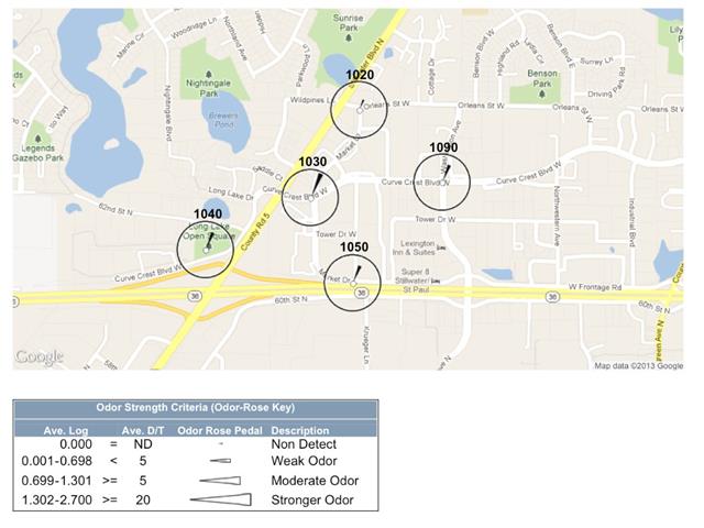
 Odor-GIS™ is a member subscription, web-based application electronic repository for all of your odor data. Odor-GIS™ is an Odor Inspection System.* Odor-GIS™ database stores your odor inspection data and graphically displays the odor data on Google Maps® and Google Earth®.
Odor-GIS™ permanently stores your odor inspection data, such as Date/Time of each inspection, odor strength D/T measurements, location code numbers, location descriptors, location GPS data, odor descriptors, and meteorological data (temperature, humidity, barometric pressure, wind direction, wind speed, precipitation, and sky cover).
The Problem: Obnoxious or bothersome odors, some of which can (may) be harmful, have caused various groups such as municipalities, private parties, facilities, sewer districts, and other governmental agencies and animal or agricultural related businesses to become concerned with the extent and potential effects of these odors and what can be done to eliminate them or at least minimize their effect.
The Solution: Odor-GIS™ provides the concerned party a visual display of the pattern of odorous air with respect to a selected or designated site so that it’s effect can be determined and if corrective action is needed and what corrective action should be taken.
Odor-GIS™ maps odor hot spots around a facility or in a community. All stakeholders can share the visual graphic data and see odors clearly.
For more information contact St. Croix Sensory to set-up your subscription, or visit the website http://www.odor-gis.com/